As the ChargePlace Scotland network continues to develop, we are improving the accessibility of our live map, to assist members in navigating to charge points on the network.
We are integrating what3words addresses into our map, changing the way we announce new charge points on social media, and helping our network members access driving directions in their preferred navigation app.
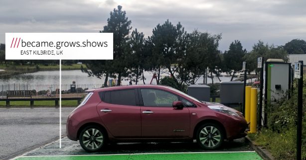
What3words addresses are now available for all charge points on our network
What3words is a tool for drivers to navigate to accurate and exact locations across the world. Where a postcode may cover a large area, what3words has divided the world into a grid of 3m x 3m squares and given each one a unique address made up of 3 words.
In 2019, we introduced 3-word addresses into all new charge point announcements on Twitter and Facebook, to help our members navigate to these charge points. Since then, many of our members have expressed the desire for what3words addresses to be displayed for all charge points on our live map…
And we listened! We are excited to announce that our members can now access 3-word addresses for all charge points on our live map.
To access what3words from the ChargePlace Scotland live map, simply click the link under the name of the charge point site or click the “Open in what3words” button on the charge point information page.
Improving how we announce new charge points on the network
Now, when we announce a new charge point on social media, we will link directly to the charge point information page that contains details of the connectors and facilities available on and around that site.
Our members can then click the “Driving directions” or “Open in what3words” buttons to open their desired map application and navigate to the charge point.
Our members can navigate to a what3words address by following the steps below:
- Click the “Open in what3words” button (or the link on the charge point on our live map).
- Select the three dots beside the address on the what3words website and click the middle button to enable navigation (or tap the “navigate” button if using the app).
- Select your preferred navigation app.
Following the instructions above will open driving directions in your preferred navigation app to direct you to the exact 3 metre square where the charge point is located.
Accessing driving directions in your preferred navigation app
We have been investigating how we can help our members use their preferred navigation app to provide directions to their desired charge point.
By default, when our members click on the “Driving directions” button on our charge point information pages, this automatically opens a link in Google Maps to help them navigate to the charge point. If you have an iPhone, this is likely to open in Apple Maps while an Android smartphone is likely to open the link in Google Maps.
As some of our members have mentioned they would prefer to use another navigation app instead of Google Maps, we are pleased to confirm this is possible on both iPhone and Android smartphones.
Here is how you can access driving directions from our live map in your preferred navigation app. Please note, these instructions will not work if you are using the Charge Your Car app.
If you are using an Android smartphone to access our live map:
- Navigate to “Apps and Notifications”, then select “Default apps” and “Opening links”.
- Scroll down the list of apps until you find Maps in your list of applications, then select “Open supported links” and “Don’t open in this app”.
- Go back to your list of apps and select your preferred navigation app, then click “Open supported links” and “Open in this app”.
- You should now see “Driving directions” opening in the application you have selected when you click this button from our charge point’s information page.
If you are using an iPhone or iPad to access our live map:
- Open the charge point you would like to navigate to on our live map and click “More info” to go through to the charge point information page.
- Press and hold the “Driving directions” button, then select “Copy link address”.
- Open your navigation app on your device, then press and hold the search bar, tap “Paste” to paste the link, and tap the “Return” key.
- This will paste the coordinates of the charge point location into your navigation app.
The approach described above will also work for navigation apps on an Android smartphone, however, you may need to remove everything else apart from the GPS coordinates (they will have a similar format to these numbers: 55.599065, -4.481653) for the app to successfully identify your destination.
Ready to join us on our mission to get Scotland driving electric? Sign up to access the network today to start your electric journey!